Seismic Degrees Map
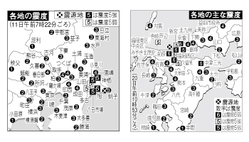
A seismic degrees map is a graphic that appears in every newspaper in the morning after an earth quake. But making the map needs much of manual work and there are often human mistakes. We developed a system which creates the map accurately and automatically using the data provided by the Meteorological Agency of Japan. Using this system, accurate maps can be created just in seconds. Also, this system automatically adjust the density of icons using the overlap avoiding function, which is powered by our unique diagrammatic recognition technology.
Completion: Oct.2006
Client: A major news distributing company
Field: Graphic, Map, Diagrammatic recognition